I. Introduction
1. Mission Overview
a. WISE
The Wide-field Infrared Survey Explorer (WISE; Wright et al. 2010, AJ, 140, 1868) is a
NASA Medium Class Explorer mission that conducted a digital imaging
survey of the entire sky in the 3.4, 4.6, 12 and 22 μm mid-infrared
bandpasses (hereafter W1, W2, W3 and W4). WISE will produce and release to
the world astronomical and
educational communities and general public a digital Image Atlas covering
the sky in the four survey bands, and a reliable Source Catalog containing
accurate photometry and astrometry for over 300 million objects.
The WISE Catalog and Atlas will enable a broad variety of research efforts
ranging from the search for the closest stars and brown dwarfs to the most
luminous galaxies in the Universe. WISE science data products will serve
as an important reference data set for planning observations and interpreting
data obtained with future ground and space-borne observatories, such as JWST.
WISE conducted its survey using a 40 cm cryogenically-cooled telescope
equipped with a camera containing four mid-infrared focal plane array
detectors that simultaneously imaged the same 47x47 arcmin field-of-view
on the sky (Figure 1). The spacecraft flew in a 526x531 km x 97.5°,
6pm ascending node, sun-synchronous polar orbit. The WISE telescope
scanned continuously at near constant Ecliptic longitudes
while a scan mirror temporarily froze the sky on the focal planes.
Sets of exposures (7.7 sec in W1 and W2 and 8.8 sec in W3 and W4)
were acquired at each point on the sky as the telescope scanned from
pole-to-pole. The FOV of each successive exposure set overlaps the
previous one by 10%, and the scan paths of adjacent orbits overlap
by approximately 90% on the Ecliptic because of the WISE orbital
precession. The number of independent exposures accumulated on each point
on the sky was typically 12 or more on the Ecliptic and increases to several
hundred at the Ecliptic poles.
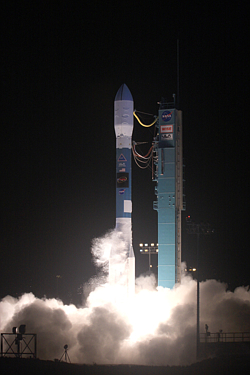
WISE was launched on a Delta II 7320 rocket from Space Launch Complex 2
at Vandenberg Air Force Base at 14:09:33 UTC on December 14, 2009 (Figure 2).
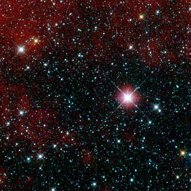
The cryogenic
telescope cover was ejected on December 29, 2009, two weeks into the
in-orbit checkout (IOC) period (Figure 3).
Nominal survey observations were started on at 11:45:53.4 UTC on
January 14, 2010 following the successful completion of the one month IOC.
Cryogenic survey operations continued uninterrupted through September 30, 2010
when the last of WISE's solid hydrogen cryogen sublimated.
After cryogen exhaustion, the two short wavelength detectors remained
operational at near cryogenic survey sensitivity. WISE continued to
survey the sky through February 1, 2011, funded by the NASA Planetary
Division, in the NEOWISE post-cryo mission phase to
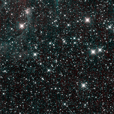
continue the pursuit of new solar system objects. Data collection with
WISE was halted after collection of the final post-cryo survey image at
11:03:01.3 UTC on February 1, 2011 (Figure 4). Final contact with the WISE
flight system was made on February 17, 2011. WISE remains in orbit,
hibernating in an inertial pointing mode with the telescope at right angles
to the Sun.
During its 413 day IOC and operational phase, WISE orbited
the Earth 6240 times, collecting 2.7 million exposures containing 7.9 trillion
pixels of information. 15.6 TB (8.6 TB compressed) of image and engineering
data were transmitted to the ground via the
TDRSS network, and ingested and processed to
produce calibrated image and extracted source data products. All components
of the WISE system operated flawlessly. No survey time was lost due to
unplanned safe holds or other unexpected behavior, and fewer than 100 image
frames were lost due to downlink errors.
Prof. Edward Wright of the University of California Los Angeles
is the WISE Principal Investigator. The WISE program is overseen by the
NASA Explorer Office at Goddard Space Flight Center. Overall project
management, project science and mission operations is the responsibility
of the Jet Propulsion Laboratory, California Institute of Technology.
Ball Aerospace and Technologies Corporation is the prime contractor for the
WISE spacecraft, and managed the Integration and Test for the program. The
Space Dynamics Laboratory at Utah State University is the prime contractor
for the WISE payload that includes the cyrogenic telescope, optics and
detector assemblies. The Infrared Processing and Analysis Center at Caltech
is responsible for WISE data ingest, processing, archiving and distribution
to the user community. Education and Public Outreach for WISE is conducted by
the University of California Berkeley.
 |
 |
 |
 |
| Figure 1 - WISE flight system in the payload processing facility
at VAFB. The domed cover was ejected two weeks after launch. |
Figure 2 - WISE launch from Vandenberg AFB at
14:09:33 12/14/09 UTC (credit: United Launch Alliance) |
Figure 3 - WISE "first-light" image taken on 12/31/10 during IOC.
This is a four-band color composite image showing a region in the constellation
Carina. |
Figure 4 - WISE "last-light" image taken on 2/1/2011. This is
two-band color composite image showing a region in the constellation Perseus.
|
b. NEOWISE
NEOWISE (Mainzer
et al. 2011 ApJ, 731, 53) is an enhancement to the primary
WISE mission data processing and archive system, funded by the NASA Planetary
Science Division, that enhances the Solar System science return
of WISE data. Dr. Amanda Mainzer of the Jet Propulsion Laboratory,
California Institute of Technology is the NEOWISE Principal Investigator.
The NEOWISE program consists of two parts. The first,
the WISE Moving Object Pipeline System (WMOPS), exploits the WISE observing
cadence that images repeatedly the same region of sky multiple times
to detect and characterize moving solar system objects, with special emphasis
on the search for Near Earth Objects. The second component of NEOWISE
provides an archive of image and source data from individual WISE
exposures that will enable enable pre-covery of WISE detections of
objects that are discovered after the end of the WISE mission.
NEOWISE/WMOPS is a software system that links non-inertial detections
made on the single-exposure WISE images made near the same point on the sky
to form candidate moving object tracklets (Figure 5). WMOPS reported
candidate tracklets to the IAU Minor
Planet Center (MPC) within 10 days of the midpoint of the WISE
observations. The MPC computed initial orbits and posted objects on their
websites for follow-up and confirmation by ground-based observers.
The first tracklet was reported to the MPC on January 9, 2010.
Since then, over 279,000 tracklets were reported, and nearly two million
individual vetted WISE mid-infrared detections of over 158,000 unique
small bodies are available from the MPC. WISE/NEOWISE has been
credited with the discovery 135 previously unknown NEOs and 17 comets,
along with over 30,000 main belt asteroids (Figure 6).
The archive component of the NEOWISE program provides for the release
of WISE single-exposure images and extracted source working database to
the science community in conjunction with the WISE primary mission
data releases. These products are accessed via the
on-line services of the NASA/IPAC
Infrared Science Archive (IRSA). This enhancement also provides an
interface query capability to the IRSA services
that enables searching for a WISE single-exposure image that covered
the predicted position of a moving object, using the object name or
orbital elements. This search capability will soon be extended to
the database of single-exposure source detections.
Under the auspices of the NEOWISE program, the NASA Planetary
Division funded the WISE post-cryo survey phase to enable the continuation
of the WISE Moving Object search. NEOWISE post-cryo operations
took place from October 1, 2010 through February 1, 2011.
 |
 |
| Figure 5 - WISE 4-band color-composite of the Tadpole Nebula
illustrating moving object tracklets. This image was formed by
combining multiple independent WISE exposures of the region without
pixel outlier rejection, so that moving objects appear multiple times.
The rectangles outline the tracklets produced by asteroids 1719 Jens and
1992 UZ5. The circled streak near the top of the image is a residual
trail left by a satellite detected in one of the WISE exposures. |
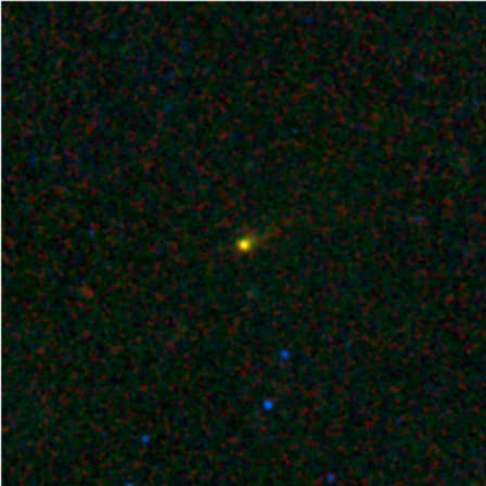
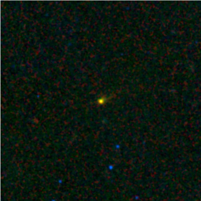
Figure 6 - Comet P/2010 B2 (WISE), the first of 17 comets
discovered by the NEOWISE program, on 1/22/2010. This is a 3-band
(4.6-12-22μm) color
composite image formed by coadding 15 independent exposures on the position
of the comet. |
c. WISE At-A-Glance
Table 1 - WISE Description
| Launch and Orbit |
| Launch | December 14, 2009; 6:09:33 PST from Vandenberg SLC2W |
| Launch Vehicle | Boeing Delta II 7320-10C |
| Orbit | 526 x 531 km x 97.5°; 6am/pm sun-synchronous |
| Orbital Rate | 3.78 arcmin/sec |
| Orbital Period | 5720 sec (95.33 min); decreasing to 5700 sec at end of on-orbit ops |
| Orbital Precession Rate | 0.986°/day = 3.92'/orbit at 95.33 min period |
| Spacecraft and Payload (see III.1 and III.2) |
| Total Mass | 459.1 kg |
| Total Power | 317.2 W |
| Spacecraft | BATC RS300 |
| Star Trackers | Two Ball CT-633 |
| Solar Panels | Fixed, 2.6 m2 |
| High-Gain Antenna | Fixed, 0.6 m diameter, Ku-band |
| Telescope Diameter | 40 cm |
| f/number | 3.375 |
| Number of Imagers and FOV | 4 all reflective. Simultaneously image same 47'x47' FOV on four detectors. |
| Number of Detectors | 4; 2 Teledyne HgCdTe, 2 DRS Si:As |
| Detector Format | 1024x1024 18μm pixels |
| Bands | W1: 3.4 μm, W2: 4.6 μm, W3: 12 μm, W4: 22 μm |
| Angular Pixel Size (IFOV) | 2.75" (W1-W3), 5.5" (W4 binned 2x2 on-board) |
| Image FWHM | W1: 6.1", W2: 6.4", W3: 6.5", W4: 12.0" |
| Detector Read-out Mode | Sample-up-the-Ramp (SUTR) |
| Exposure Time | 7.7 sec (W1 and W2), 8.8 sec; 8x1.1 sec samples (1st sample dropped for W1/W2) |
| Exposure cadence | 11 sec |
| Image Data Rate | 4.65 Mbps to Spacecraft
50.6 GB/day uncompressed
~20.6 GB/day with lossless Rice compression |
| Downlink Services | TDRSS Ku-band; 20 W transmitter + SSA; 100 Mbps downlink rate |
| Contacts Schedule | 54 minutes/day @ 51 MBps effective link; 4 contacts/day on average |
| Survey Strategy (see III.4) |
| Data Acquisition Mode | Freeze-frame scanning. Near-zenith-pointing telescope scans continuously while scan mirror freezes sky on focal planes for 11 sec. |
| Frame-to-Frame (in-scan) Overlap | 5.39' (11.49%) at 11 sec cadence |
| Survey Scan Angular Velocity | ω = (0.0125,3.7977,0) arcmin/sec |
| Longitude step between orbits | +30.65' / -22.15' |
| Orbit-to-Orbit (cross-scan) Overlap | Average of 42.68' (90.9%) on Ecliptic plane. Increases towards poles. |
| Sky Coverage | Typically 12 independent exposures near the Ecliptic Plane, increasing towards Ecliptic poles. |
| Photometric System (see IV.3.g) |
| Band Center for Vega-like Spectrum | W1: 3.35 μm, W2: 4.60 μm, W3: 11.56 μm, W4: 22.09 μm |
| Band width for Vega-like Spectrum | W1: 0.66 μm, W2: 1.04 μm, W3: 5.51 μm, W4: 4.10 μm |
| Flux for 0 Magnitude (Vega) | W1: 306.68 ± 4.60 Jy, W2: 170.66 ± 2.56 Jy, W3: 29.045 ± 0.436 Jy, W4: 8.2839 ± 0.2899 Jy |
| Data Release and Primary Products (see I.2) |
| Data Release Schedule | Preliminary: April 14, 2011 Final: Spring 2012 |
| Preliminary Release Scope | ~57% of sky, survey data from January 14 to April 29, 2010 |
| Preliminary Release Image Atlas | 10,464 Atlas Image Sets - FITS format, 4 bands x intensity, depth-of-coverage, uncertainty images |
| Preliminary Release Source Catalog | Source Catalog - positions and photometry for 257,310,278 objects |
Table 2 - WISE Mission Events
| Date (UTC) | Event |
|---|
| 12/14/2009 |
Launch from Vandenberg AFB. IOC Start. |
| 12/29/2009 |
Cover eject |
| 12/31/2009 |
First light. Start of Provisional Data Processing |
| 01/07/2009 |
Near survey quality observations begin |
| 01/13/2009 |
End of IOC |
| 01/14/2009 |
Start of 4-band cryogenic survey operations |
| 04/20/2010 | Start of First-pass Data Processing |
| 07/17/2010 |
First sky coverage completed |
| 08/05/2010 |
Secondary cryogen tank exhaustion |
| 09/29/2010 |
Primary cryogen tank exhaustion |
| 10/01/2010 |
Start of post-cryo survey operations |
| 01/09/2011 |
Second sky coverage completed |
| 02/01/2011 |
End of post-cryo survey operations |
| 02/17/2011 |
Flight-system decommissioned |
| 04/14/2011 |
Preliminary Data Release |
| April 2011 | Start of Second-Pass Data Processing |
| Spring 2012 |
Final Data Release |
Table 3 - Preliminary Release Achieved Performance
| | Level 1 Requirement | Achieved |
Sky Coverage
(VI.2) | ≥4 independent exposures in each filter on at least 95% of the sky | ≥4 coverages on >99% of the sky, all bands.
95% of sky
has 10.0/9.9/9.0/9.4 coverages in W1/W2/W3/W4
(Preliminary Data Release covers 57% of the sky) |
Photometric Sensitivity
(VI.4.a) | SNR=5 at 0.12/0.16/0.85/4.0 mJy (16.0/15.1/11.3/8.3 Vega mag) at W1/W2/W3/W4 in unconfused regions with 8 coverages | 0.05/0.10/0.73/5.9 mJy (17.0/15.6/11.5/7.9 Vega mag) based on comparison with external measurements |
Photometric Accuracy
(VI.4.b) | RMS error in relative accuracy <7% accuracy for SNR>100 | RMS = 0.02 mag (W1/W2/W3) and 0.03 mag (W4) |
Astrometric Accuracy
(VI.5) | RMS position error with respect to the 2MASS PSC <0.5" for SNR>20 in at least one band | RA and Dec RMS~0.2" for W1<13.0 mag.
Increasing fraction of fainter sources exhibit a systematic declination bias of
0.2-1.0". Approx. 20% of sources with W1<14.5 mag are affected. |
Catalog Completeness
(VI.6) | >95% for SNR>20 in unconfused regions | > 95%
for sources with W1<16.6, W2<16.0, W3<10.8,
W4<6.7 Vega mag in unconfused
regions with ≥12 frame depth-of-coverage |
Catalog Reliability
(VI.7) | >99.9% for SNR>20 in unconfused regions | >
99.9% for sources with W1<15.6,
W2<14.3, W3<10.2, W4<6.5 mag in unconfused
regions with ≥12 frame depth-of-coverage. |
d. The WISE Preliminary Data Release
The WISE Preliminary Data Release is the first release of a large
quantity of WISE image and extracted source data to the scientific
and educational community. The Release includes data from the
first 105 days of the WISE cryogenic survey, covering approximately
57% of the sky. An executive summary of the Release data products is
given in section I.2. The goal of this early
release is to provide a significant data set to the scientific community as
quickly as possible following the end of mission operations that will
introduce users to the WISE data, and will
enable a broad range of investigations. The Preliminary Data Release
also enables the WISE Project Team to exercise and refine data preparation
and release processes prior to the final release in 2012.
The WISE Preliminary Release products are not the ultimate realization
of the WISE data. The Preliminary Release products are generated from
the results of first-pass WISE
data processing that started
just three months following the survey start. Processing was done with
an early version of the Wise Science Data
System (WSDS) that was based on pre-launch and very early survey
calibrations
and reduction algorithms. Detection thresholds and source selection criteria
for the Preliminary Release Source Catalog were conservative with the emphasis
put upon providing a reliable yet representative sample of WISE data.
As a result of the rapid deployment necessary to meet the schedule for the
Preliminary Data Release, the Preliminary Release products did not
benefit from much of the experience gained over the full mission lifetime.
Consequently, the Preliminary Release products contain a number of known
features and limitations that are documented in I.4.
Users are strongly recommended to familiarize themselves with the known
idiosyncracies of the WISE data products documented therein.
All WISE cryogenic survey data will undergo a planned, complete
second-pass processing using
an updated version of the WSDS that incorporates corrections to deficiencies in
first-pass processing, and improved
calibrations and processing algorithms developed from analysis of the
full mission data set. The results of the second-pass processing will be used
to generate the WISE Final Data Release products that will be
issued in the Spring of 2012.
e. About this Document
This Explanatory Supplement provides users of WISE products with a
description of the overall WISE survey and data products. An executive
summary of the Preliminary Data Release products is available in
Section I.2, and known features and
limitations in Section I.4.
Section II contains a more detailed user's guide
to the products, with information about their content and characteristics. In Section III, the WISE flight system, operations and survey strategy are presented. Detailed descriptions of the
functions and algorithms of the WSDS are described in
Section IV. Generation of the final Image Atlas and
Source Catalog are described in Section V, and
detailed descriptions of the achieved performance and quality
of the Preliminary Release data products are presented in
Section VI.
This Explanatory Supplement is a living
document that will be updated frequently to provide
the most current information for users of the WISE data products.
Please see the Document
Change History for a record of the latest updates.
Last update: 2011 August 17
Next page
Return to Explanatory Supplement TOC