


WISE scans the sky in great (semi-)circles approximately perpendicular to the Earth-Sun line. Each scan is at a constant inertial rate, with an angular velocity in the spacecraft coordinate given by ω = (0.0125,3.7977,0) arc-min/sec. The x-axis points along the orbital velocity, the y-axis points is the normal to the solar panels, and the z-axis is along the line-of-sight of the telescope. The angular scan rate is close to but not exactly equal to the orbital rate of 3.78 arc-min/sec. The actual scan rate is chosen to match the rate of the scan mirror in the payload that was used to cancel the motion of images on the detector arrays for 9.9 seconds out of the 11 second frameset to frameset cadence. The remaining 1.1 seconds contained the flyback of the scan mirror.
The small x-axis rate is compensating for a small shift in the effective rotation axis of the scan mirror from the y-axis of the spacecraft.
Each time WISE passed over a pole a new scan was started. In resetting the position for a new scan semi-circle the approximately one degree of offset in pitch (rotation around the y-axis) due to the mismatch between the scan rate and the orbital rate is combined with several degrees of change in yaw (rotation around the z-axis) generated by the survey strategy.
The arrays are readout 9 times with a 1.1 second spacing during the exposure, and the nine values are combined on-board into a single value for the fitted slope while sampling up the ramp. The readout actually takes about 1.05 seconds to sweep through the array so there is variation of the actual center of the integration time depending on position within the array. In addition, the two short wavelength arrays showed a first sample anomaly so the first sample was dropped by adjusting the weights for the slope fit. As a result W1 and W2 have a 7.7 second exposure time while W3 and W4 have an 8.8 second exposure time, and the W1 and W2 exposures start 1.1 seconds later than the W3 and W4 exposure. This effect can easily be seen in satellite streaks seen on individual frames.
The WISE line of sight advances by 42' per exposure resulting in ~10% areal overlap between adjacent exposures. The orbital scan precession rates produces ~90% overlap in the ecliptic longitude direction between adjacent orbits. Figures 1 and 2 illustrates how this redundancy builds up sky coverage during the survey. Figures 4 and 5 show the actual accumulated depth-of-coverage for the full survey and the period covered by data in the Preliminary Data Release.
 |
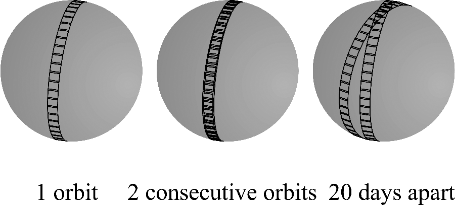 |
| Figure 1 - Coverage by WISE in one exposure, in one orbit, in two orbits, and in many orbits. The colors show the depth of coverage with the red being a single exposure and blue being the deepest coverage. | Figure 2 - WISE coverage (not to scale) on the sphere for 1 orbit, for 2 consecutive orbits, and for 2 orbits separated by 20 days, illustrating the highly redundant coverage at the ecliptic poles. |
The resulting scan longitudes are:
| λ1 = λSun+90+DIHEDRAL+BIAS+(-1)N*TOGGLE+y1(t)*MOONAVOID | (Eq. 1) |
for the longitude of the scan in front of the Sun (6 PM side of the orbit), and
| λ2 = λSun-90-DIHEDRAL+BIAS+(-1)N*TOGGLE+y2(t)*MOONAVOID | (Eq. 2) |
for the longitude behind the Sun on the 6 AM side of the orbit.
When the scan would be within 5 degrees of Moon the longitude is changed to be 5 degrees from the Moon. Thus the minimum distance between the line-of-sight and the Moon is 5 degrees.
The start times of the scans are given by
| T2 = TDN-P/4+(-1)N*(PROTECT+SETTLE/2)-SETTLE/2 | (Eq. 3) |
for the descending (6 AM) side of the orbit, and
| T1 = T2+P/2 | (Eq. 4) |
for the ascending (6 PM) side of the orbit. Here TDN is the time of the descending node passage, P is the orbital period, and PROTECT = 60 seconds allows for an undisturbed scan through the ecliptic pole, and SETTLE = 120 seconds is an allowance for the settling time of the spacecraft after a slew. The descending node time is defined as the time the ecliptic latitude of the spacecraft crosses from North to South.
Figure 3 shows the ecliptic longitude of the WISE scan semi-circles as a function of day of 2010, for actually executed survey scans. The small toggles on every other orbit smooth out the influence of the South Atlantic Anomaly, and the monthly sawtooth is the moon moon avoidance maneuver.
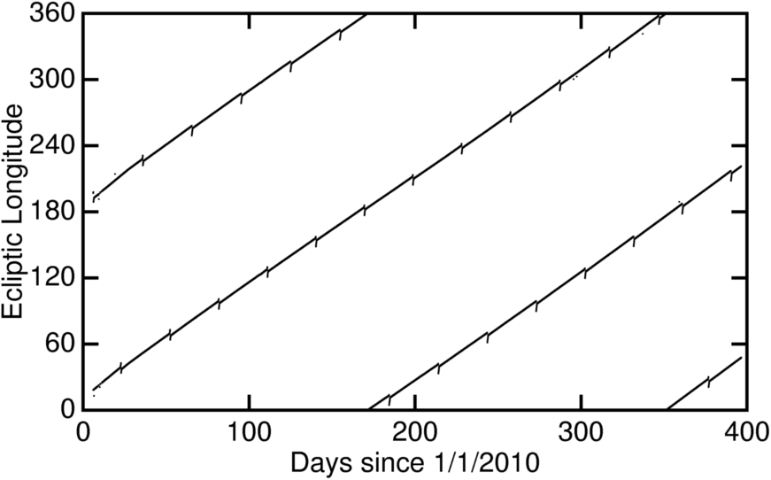 |
| Figure 3 - Actual ecliptic longitude of the scan semi-circles as a function of day of 2010, for actually executed survey scans. |
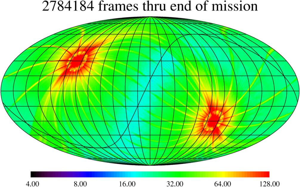
The nominal depth-of-coverage of all WISE exposure acquired during the full cryogenic and post-cryo survey phases is shown in Figure 4. 2,784,184 exposures were taken and downlinked. Figure 5 shows the nominal coverage for the 6,325 scans taken during between 7 January and 6 August 2010, the full cryogenic survey period represented in the WISE All-Sky Data Release (V.2). 1,491,686 single-exposure framesets were acquired and downlinked during this period. Not all of these framesets were used in Multiframe Pipeling processing, though. The effective sky coverage achieved by WISE when taking into account data quality is discussed in VI.2.
 |
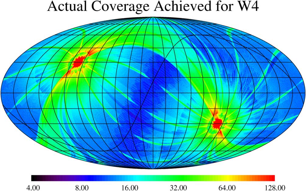 |
| Figure 4 - Galactic projection map showing the nominal depth-of-coverage accumulated by WISE during the cryo and post-cryo mission phases. | Figure 5 - Galactic projection map showing the nominal depth-of-coverage accumulated by WISE during the range of scans included in the All-Sky Data Release. |
Last update: 2012 January 31