| The Wide-field Infrared Survey Explorer at IPAC |
 |
All-Sky Data Release March 14, 2012 |
 |
NASA's Wide-field Infrared Survey Explorer (WISE; Wright et al. 2010) mapped the sky at 3.4, 4.6, 12, and 22 μm (W1, W2, W3, W4) in 2010 with an angular resolution of 6.1", 6.4", 6.5", & 12.0" in the four bands. WISE achieved 5σ point source sensitivities better than 0.08, 0.11, 1 and 6 mJy in unconfused regions on the ecliptic in the four bands. Sensitivity improves toward the ecliptic poles due to denser coverage and lower zodiacal background.
The All-Sky Release includes all data taken during the WISE full cryogenic mission phase, 7 January 2010 to 6 August 2010, that were processed with improved calibrations and reduction algorithms. Release data products include an Atlas of 18,240 match-filtered, calibrated and coadded image sets, a Source Catalog containing positional and photometric information for over 563 million objects detected on the WISE images, and an Explanatory Supplement that is a guide to the format, content, characteristics and cautionary notes for the WISE All-Sky Release products. The WISE All-Sky Data Release products supersede those from the April 2011 Preliminary Data Release.
All-Sky Release ancillary products include a Reject Table containing 284 million detections that were not selected for inclusion in the Source Catalog because they are low signal-to-noise ratio or spurious detections of image artifacts, an archive of over 1.5 million Single-exposure Image sets and a database of over 9.4 billion source extractions from those images, and moving object tracklets identified as part of the NEOWISE program (Mainzer et al. 2011).
Please include this acknowledgment in any published material that makes use of WISE data products.
Research using WISE Release data is eligible for proposals to the NASA ROSES Astrophysics Data Analysis Program.
WISE imaged the entire sky with multiple, independent exposures
during its full cryogenic survey. All four bands were imaged simultaneously
during each exposure, and the exposure times were 7.7 sec in W1 and W2
and 8.8 sec in W3 and W4. As illustrated in Figure 1, the
survey scanning strategy resulted in 12 to 13 exposures of
each point on the ecliptic plane. Coverage increases to over 3000 exposures at
the ecliptic poles. WISE completed its first complete sky
coverage on 17 July 2010 and surveyed approximately 20% of the sky
a second time before the end of the full cryogenic mission phase.
All of the individual exposures that met minimum requirements for
image quality and noise levels were combined to form the All-Sky Release
Image Atlas and Source Catalog. The localized decreases in coverage in
small areas seen in Figure 1 are the result of exclusion of lower quality
exposures. Additionally, coverage depth was artificially capped at
approximately 160 exposures near the ecliptic poles for processing
runtime and memory usage requirements.
A plot of the approximate differential area as a function of the average
W1 exposure depth-of-coverage realized in the All-Sky Release Atlas
and Source Catalog is shown in Figure 2. The peak near 12 coverages
corresponds the ecliptic plane in the nominal survey, and the secondary
peak at 24 coverages is the ecliptic plane in the two-epoch coverage
part of the sky. The peak near 160 coverages and maximum depth near
250 result from the artificial attenuation of the
coverage near the ecliptic poles.
Pixel-level frame effective coverage information is provided in the
WISE Image Atlas depth-of-coverage maps.
The WISE Image Atlas is comprised of 18,240 4095x4095 pixel
@1.375"/pix FITS format image sets.
One image set is produced for each Atlas Tile. The
1.564°x1.564° Atlas Tiles are built on an equatorial projection
and are distributed in 119 iso-declination bands with 238 Tiles on
the celestial equator and six Tiles in the |δ|=89.35°
declination band. Tiles overlap by 180" in RA and Dec on the equator, and
the RA overlap increases towards the equatorial poles.
Each Atlas Image set consists of:
The headers of each Atlas Image provide WCS information to convert pixel to
equatorial coordinates and photometric zero points for calibration
of relative photometry.
See section II.3 of the WISE All-Sky
Release Explanatory Supplement for more information about the content,
format, and properties of the Image Atlas.
The WISE Source Catalog contains the attributes
for 563,921,584 point-like and resolved objects detected on the
Atlas Intensity images.
Catalog sources are required to have a measured
SNR>5 in at least one band, and to meet other criteria
to insure a high degree of reliability.
Attributes included for each entry in the Source Catalog include:
Relative photometric calibration for WISE source photometry is made using
measurements of a network of calibration standard stars near the ecliptic
poles. The WISE bandpasses and relative spectral response curves
are available
in Section IV.4.h.v of the
WISE All-Sky Release Explanatory Supplement.
See section II.2 of the WISE All-Sky Release
Explanatory Supplement for more information about the content,
format, and properties of the Source Catalog.
In addition to the Image Atlas, Source Catalog and Explanatory
Supplement, the WISE All-Sky Release includes several ancillary
data products.
See section II.4 of the WISE All-Sky
Release Explanatory Supplement for more information about the content,
format, and properties of each of the Ancillary Products.
The WISE All-Sky Release data products can be accessed
via the on-line and machine-friendly services of the
NASA/IPAC Infrared
Science Archive (IRSA). IRSA services are VO compatible.
See section I.3 of the WISE All-Sky
Release Explanatory Supplement for a complete description of how
to access WISE data products.
Please include the following in any published material that makes use of the
WISE data products:
"This publication makes use of data products from the Wide-field Infrared
Survey Explorer, which is a joint project of the University of California,
Los Angeles, and the Jet Propulsion Laboratory/California Institute of
Technology, funded by the National Aeronautics and Space Administration."
Thank you very much.
General information about the WISE All-Sky Data Release
Sky Coverage Statistics
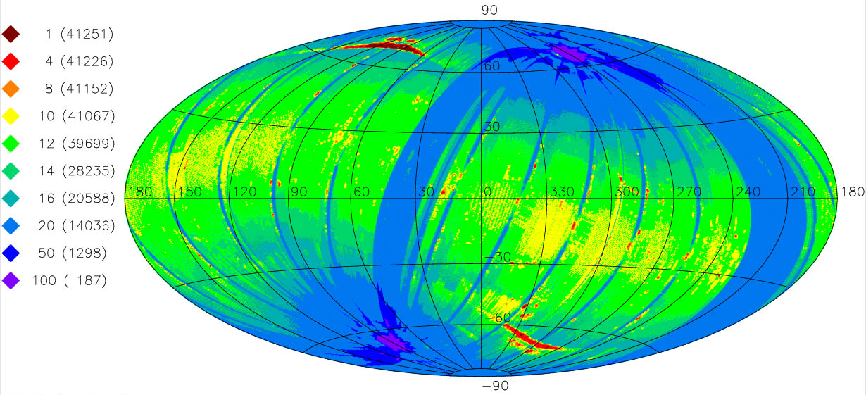
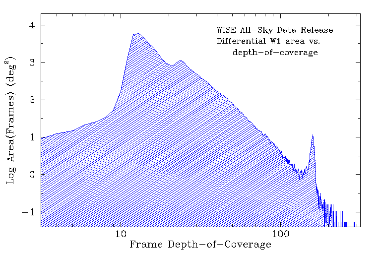
Figure 1 - Equatorial Aitoff projection sky map showing
the average number of individual 7.7 sec (W1 and W2) and 8.8 sec (W3 and W4)
exposure frames
within 14´ × 14´ spatial bins going into the WISE All-Sky
Release Atlas and Catalog.
Colors encode different frame depths-of-coverage, and the legend on the left
gives the cumulative area in square degrees
as a function of coverage depth.
Figure 2 - Differential area as a function of average W1 frame
depth-of-coverage in the All-Sky Release Atlas and Catalog,
computed in 14´ × 14´ spatial bins.
Image Atlas
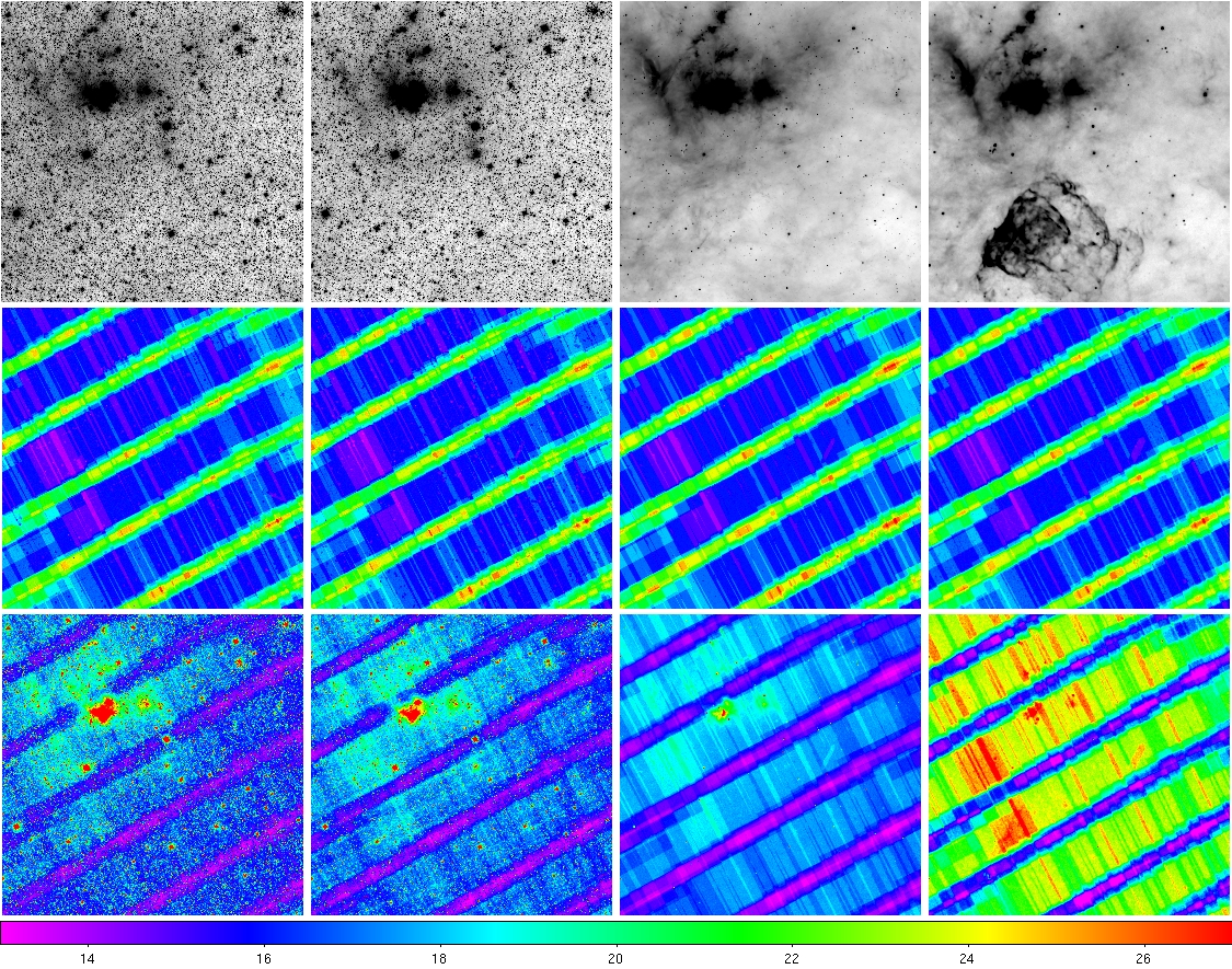
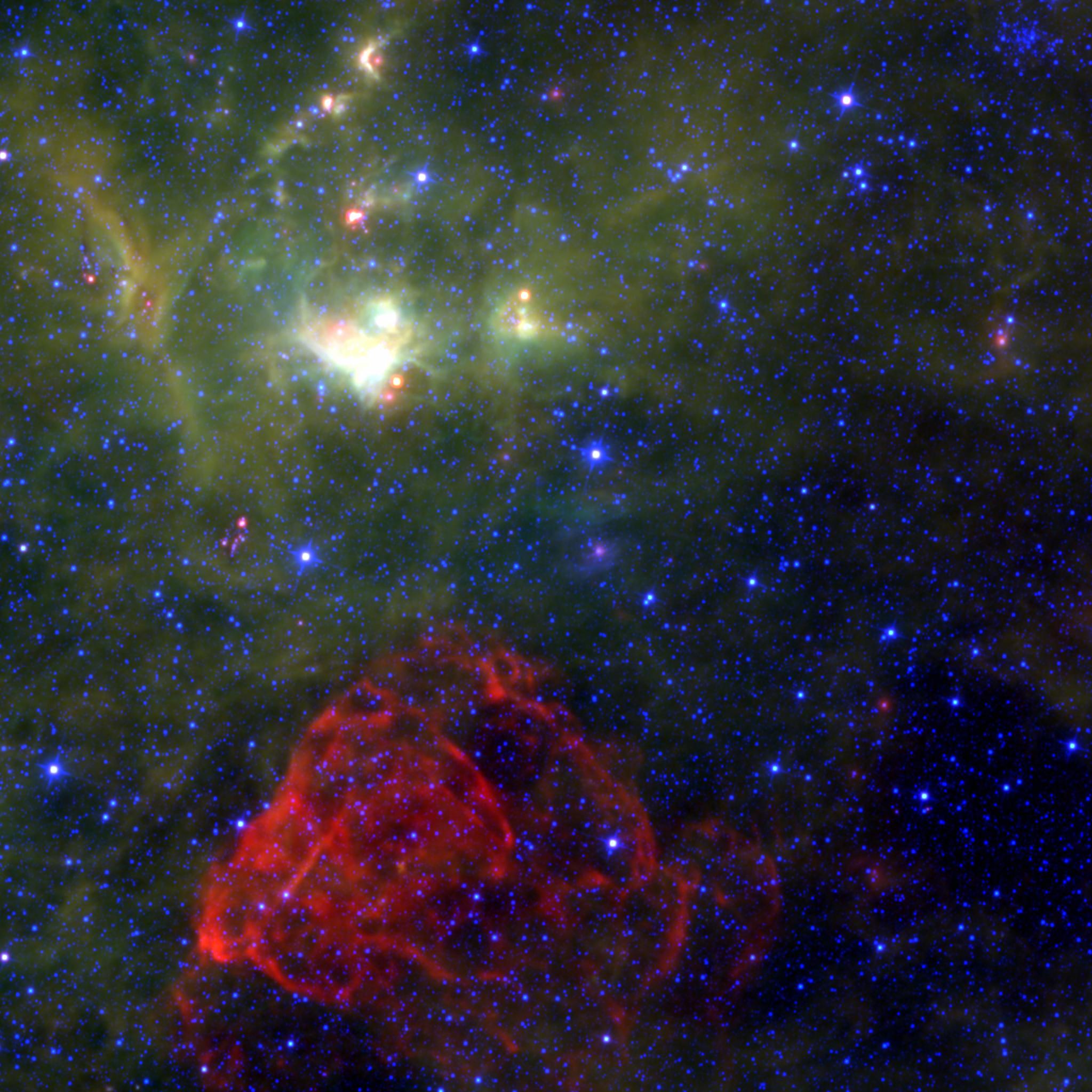
Figure 3 - (left, top row) 3.4, 4.6, 12, 22 μm
intensity images, (left, center row)
depth-of-coverage maps, and (left, bottom row)
uncertainty maps for
the Atlas Tile 1253m425_ab41 that contains
the Puppis A supernova remnant. The color scale on the bottom of the
grid refers to the depth-of-coverage maps.
(above) 4.6, 12, 22 μm 3-color composite intensity map of Tile 1253m425_ab41.
Source Catalog
in unconfused regions on the ecliptic
plane. Sensitivity is better at higher ecliptic latitudes where
coverage is deeper and the zodiacal background is lower, and poorer
when limited by confusion in high source density or complex background
regions. Saturation affects photometry
for sources brighter than approximately 8.1, 6.7, 3.8 and -0.4 mag
at 3.4, 4.6, 12 and 22 μm, respectively.
Ancillary Products
Data Access
Standard Acknowledgment for Use of WISE Data in Publications
Last update - 2013 March 21
 |
 |
 |
 |