| The Wide-field Infrared Survey Explorer at IPAC |
NASA's Wide-field Infrared Survey Explorer (WISE; Wright et al. 2010) mapped the sky at 3.4, 4.6, 12, and 22 μm in 2010 with an angular resolution of 6.1" 6.4" 6.5" & 12.0" in the four bands. WISE achieved 5σ point source sensitivities better than 0.08, 0.11, 1 and 6 mJy in unconfused regions on the ecliptic in the four bands. Sensitivity improves toward the ecliptic poles due to denser coverage and lower zodiacal background.
The WISE Preliminary Release includes data from the first 105 days of WISE survey observations, 14 January 2010 to 29 April 2010, that were processed with initial calibrations and reduction algorithms. Primary release data products include an Atlas of 10,464 calibrated, coadded Image Sets, a Source Catalog containing positional and photometric information for over 257 million objects detected on the WISE images, and an Explanatory Supplement that provides a user's guide to the WISE mission and format, content, characteristics and cautionary notes for the Release products. Ancillary release products include an archive of over 754,000 Single-exposure Image sets and database of over 2.2 billion source extractions from those images, and moving object tracklets identified as part of the NEOWISE program (Mainzer et al. 2011).
Access to the WISE Preliminary Release Image and Source data products is via the on-line services of the NASA/IPAC Infrared Science Archive (IRSA). NEOWISE-reported moving object tracklets are accessed from the IAU Minor Planet Center.
Research using WISE Preliminary Release data is eligible
for proposals to the 2011
NASA ROSES Astrophysics Data Analysis Program. Additional information on
the ADAP is provided in Appendix D.2 of ROSES.
Please include this acknowledgment in any
published material that makes use of WISE data products.
General information about the WISE Preliminary Data Release
 |

|
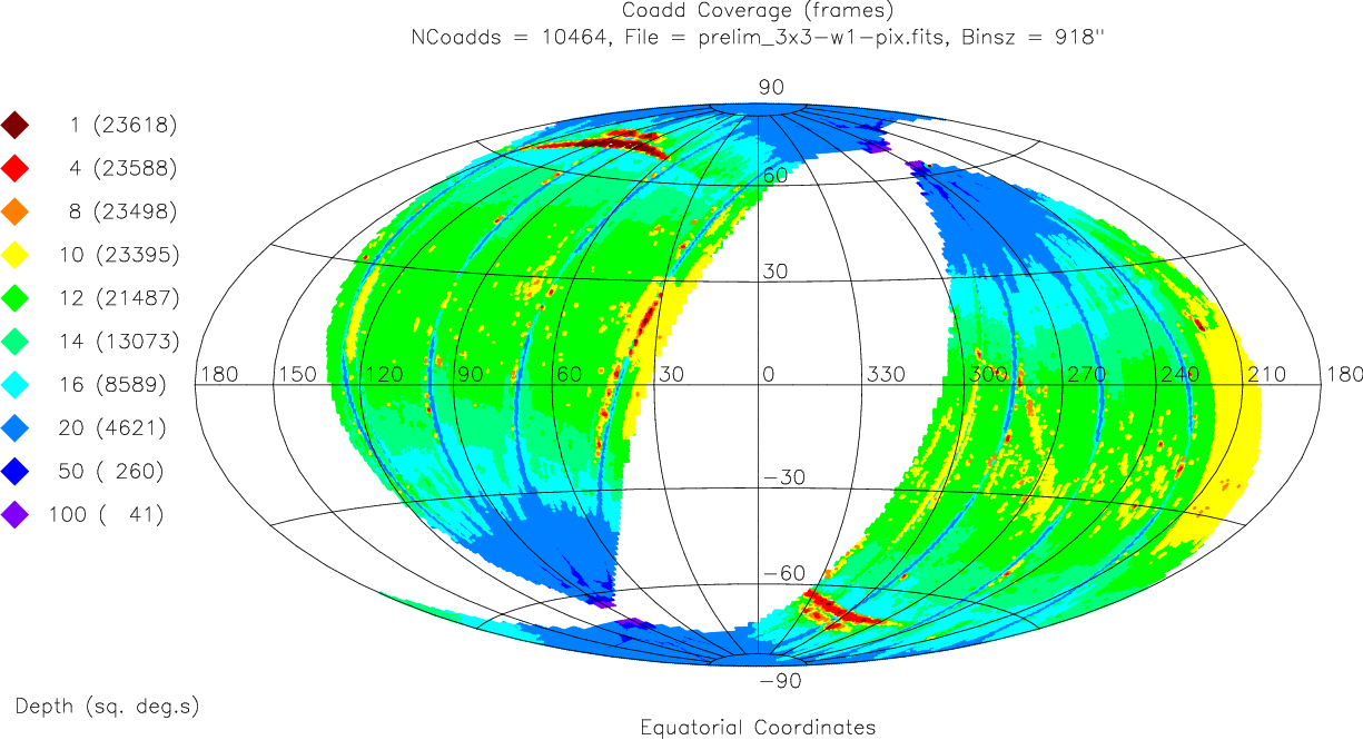
| Figure 1 - Equatorial aitoff projection sky map showing the area covered by the WISE Preliminary Data Release. The colors encode the average number of single 7.7/8.8 sec WISE exposure frames covering 15´ × 15´ bins. The legend on the left gives the cumulative area in square degrees as a function of frame coverage depth. | Figure 2 - Differential area as a function of average frame depth-of-coverage in the Preliminary Release, computed in 15´ × 15´ bins. |
The Atlas and Source Catalog of the WISE Preliminary Data Release cover approximately 23,600 deg2, or 57% of the sky. The release area consists of two large regions bounded approximately by the ecliptic longitude ranges:
The survey depth-of-coverage varies across the sky because of the WISE scanning strategy, as shown in Figure 1. There are typically 12 independent exposure framesets contributing to each point on the sky near the ecliptic plane. All four bands were imaged simultaneously, and the exposure times were 7.7 sec in W1 and W2 and 8.8 sec in W3 and W4. The frame depth-of-coverage increases towards the ecliptic poles, reaching a maximum of ~260 frames at the highest ecliptic latitudes in the Preliminary Release (Figure 2). Local decreases in frame coverage are caused by filtering out exposures that are considered to be of lower quality because of contamination by scattered moonlight (within 20° of the ecliptic), image quality degradation due to flight system motion, or other events. Pixel-level frame coverage information is provided in the WISE Image Atlas depth-of-coverage maps.
The WISE Preliminary Data Release area is comprised of 10,464 Atlas Tiles, each Tile being 1.564°x1.564° in size and built on an equatorial projection. The full sky is tessellated with a grid of 18,240 Tiles for the purpose of combining the WISE Single-exposure images and extracting final source information. The Tiles are distributed in 119 iso-declination bands with 238 Tiles on the celestial equator and six Tiles in the |δ|=89.35° declination band. Tiles overlap by 180" in RA and Dec on the equator, and the RA overlap increases towards the equatorial poles. The 10,464 Tiles included in the Preliminary Release are the subset that are fully contained within the ecliptic longitude range given above.
Use the following service to determine if a location or object is in the Preliminary Release area, and if so, the Tile in which is located.
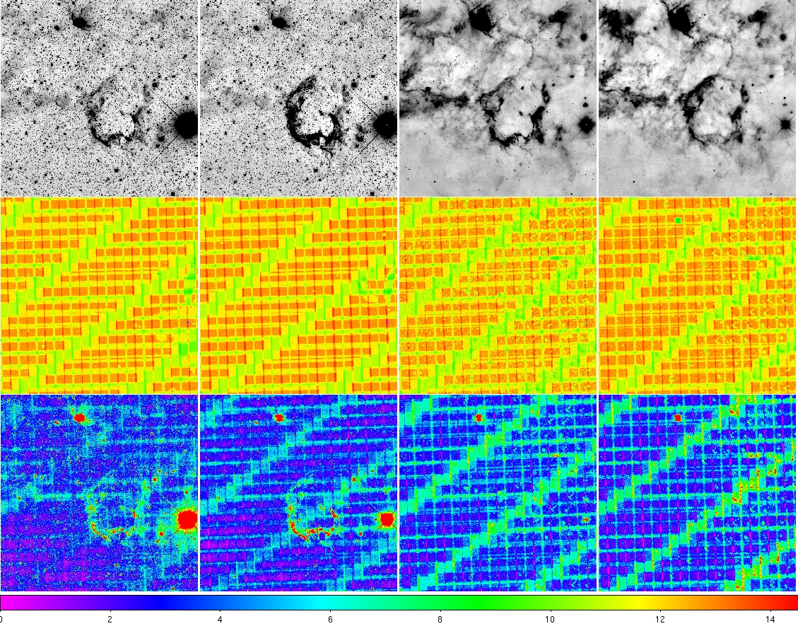 |
Figure 3 - (top row) 3.4, 4.6, 12, 22 μm intensity images, (center row) depth-of-coverage maps, and (bottom row) uncertainty maps for the Atlas Tile 0944p227_aa11 that contains the supernova remnant IC443. The color scale on the bottom of the picture refers to the depth-of-coverage maps. |
The WISE Image Atlas is comprised of 10,464 4095x4095 pix @1.375"/pix FITS format image sets. One image set is produced for each Atlas Tile. Each image set consists of:
The headers of each Atlas Image provide WCS information to convert pixel to equatorial coordinates and photometric zero points for calibration of relative photometry.
The WISE Source Catalog contains the attributes for 257,310,278 objects detected on the Atlas Intensity images. Catalog sources are required to have a measured SNR>7 in at least one band, a conservative level for the Preliminary Release to emphasize Catalog reliability. Attributes included for each entry in the Source Catalog include:
Relative photometric calibration for WISE source photometry is made using measurements of a network of calibration standard stars near the ecliptic poles. Information about the WISE bandpasses and relative spectral response curves is available in Section IV.3.g of the WISE Preliminary Release Explanatory Supplement.
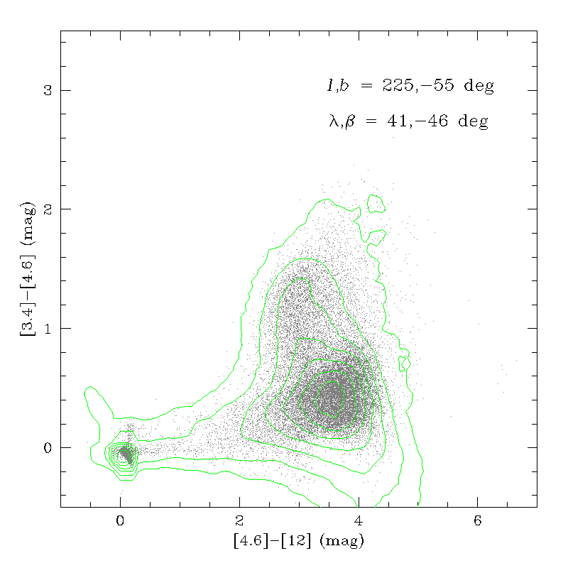
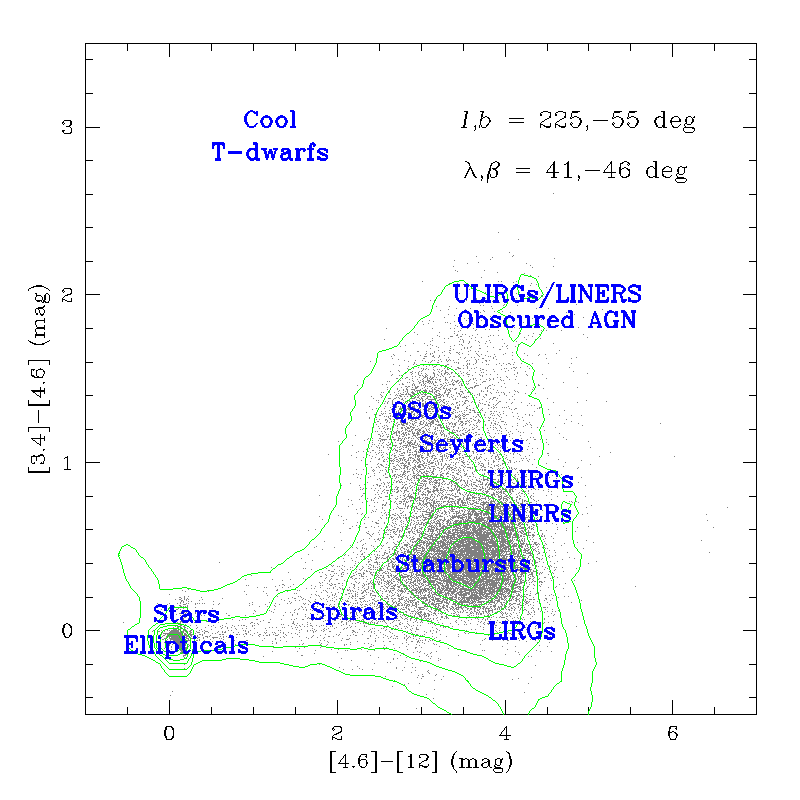
3.4-4.6-12 μm color-color diagrams drawn from high and low galactic latitude regions in the Preliminary Data Release Source Catalog are shown in Figures 7 and 8, respectively.
 |
 |
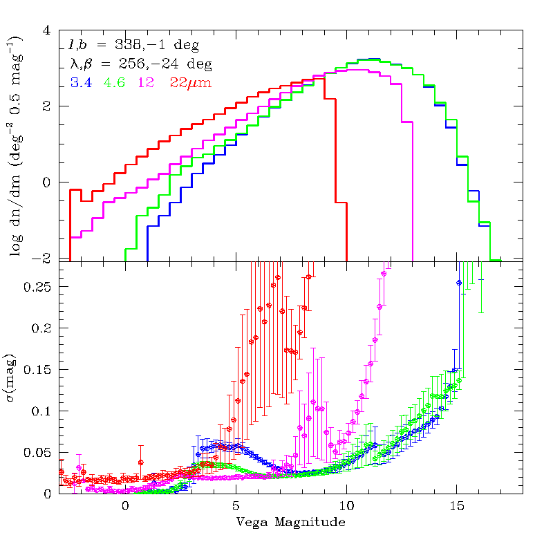 |
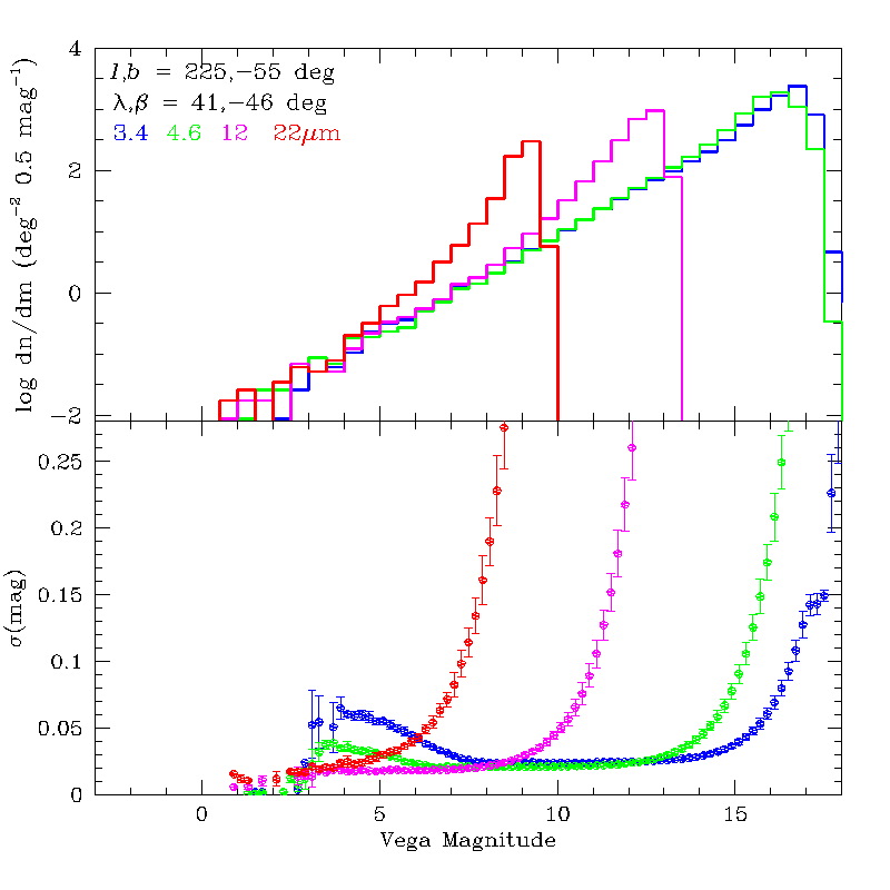
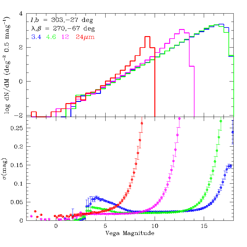
| Figure 4 - (top) Differential WISE Source Catalog counts in a 116 deg2 near l,b=225°,-55° with average frame depth-of-coverage of ~16. (bottom) Average photometric uncertainty as a function of source brightness. | Figure 5 - (top) Differential WISE Source Catalog counts in a 125 deg2 near l,b=303°,-27° with average frame depth-of-coverage of ~24. (bottom) Average photometric uncertainty as a function of source brightness. | Figure 6 - (top) Differential WISE Source Catalog counts in a 116 deg2 near l,b=338°,-1° with average frame depth-of-coverage of ~16. (bottom) Average photometric uncertainty as a function of source brightness. |
 |
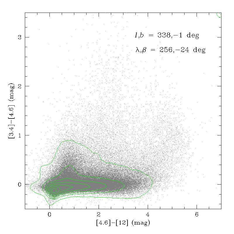 |
| Figure 7 - WISE 3.4-4.6-12 μm color-color diagram for a 116 deg2 region at l,b=225°,-55°. Green contours trace the density of sources in color bins. Click here for an annotated version of the color-color diagram showing the location of different classes of objects. | Figure 8 - WISE 3.4-4.6-12 μm color-color diagram for a 116 deg2 region at l,b=338°,-1°. Green contours trace the density of sources in color bins. |
In addition to the Image Atlas, Source Catalog and Explanatory Supplement, the Preliminary WISE Release will include several ancillary data products.
Access to the WISE Preliminary Release data products initially will be via the on-line services of the NASA/IPAC Infrared Science Archive (IRSA). IRSA services are VO compatible.
Simple and complex queries on tabular data products including the Source Catalog, single-exposure source database, known solar system object possible associations, and image metadata tables can be made using the IRSA/GATOR general catalog query engine.
The IRSA/WISE Image Service (Figure 9) enables viewing and downloading WISE Atlas and Single-exposure image sets using via position/area-based and object named queries, including a special solar-system object name or orbital element search capability for the Single-exposure images.
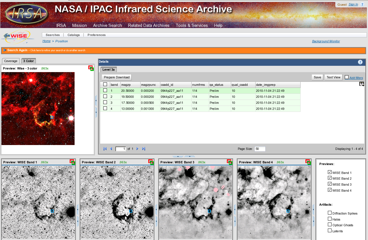 |
| Figure 9 - Screen capture showing the result page returned by the IRSA/WISE Image Service for the WISE Atlas Image covering the supernova remnant IC443. |
Please include the following in any published material that makes use of the WISE data products:
"This publication makes use of data products from the Wide-field Infrared Survey Explorer, which is a joint project of the University of California, Los Angeles, and the Jet Propulsion Laboratory/California Institute of Technology, funded by the National Aeronautics and Space Administration."
Thank you very much.
 |
 |
 |
 |