The WISE survey data acquisition strategy, data processing and quality
assurance measures were all designed to yield data products of high
reliability and fidelity. However, the accelerated schedule of the
Preliminary Release combined with challenge of validating such a large
data set in a limited time, resulted in a number of limitations and
problems that persist into the Preliminary Release products.
The following sections contain summaries of known features and
limitations that pertain to WISE Preliminary Data Release data products.
Section I.4.a presents general Cautionary Notes. Sections
I.4.b and I.4.c
address essential information concerning the Source Catalog and Image Atlas,
respectively. Section I.4.d
contains Cautionary Notes for users who make use of the Release Ancillary
Data products, including the Single-Exposure
Source Database and Image Archive,
and the Known Solar System Object Possible
Candidate Association Table.
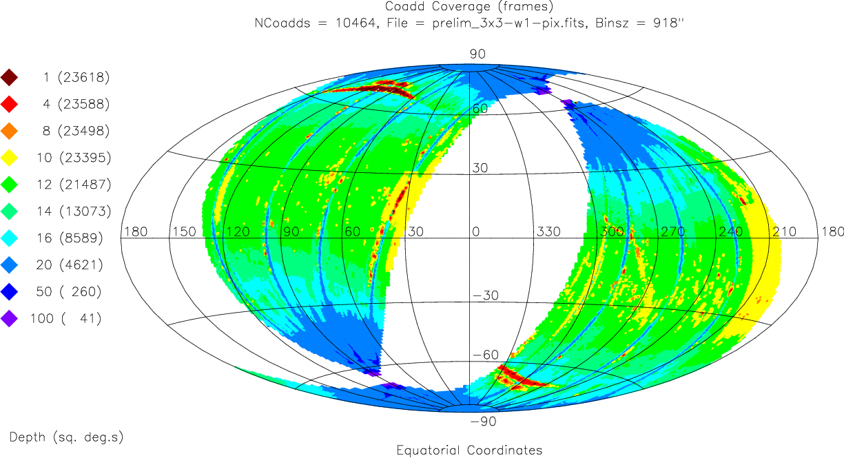
The WISE Preliminary Release does not cover the entire
sky. By design, the WISE Preliminary Release products were generated using
only data acquired during the first 105 days of cryogenic survey operations
(V.2).
This resulted in products that cover approximately 57% of the sky
(~23,600 deg2), in two large contiguous regions approximately
bounded by ecliptic longitude limits
27.8°<λ<133.4° and 201.9°<λ<309.6°
(Figures 1, 2 and 3).
The WISE Final Data Release scheduled for the Spring of 2012 will
incorporate all cryogenic survey data covering the full sky.
Detailed statistics of the effective sky coverage in the
WISE Preliminary Data Release are presented in VI.2.
The following online service uses actual Tile boundaries
to determine if a user-specified object or location of interest is within
the nominal boundaries of the Preliminary Release, and if so, in which
Tile it is located.
The coordinates of Preliminary Release Tile corners in ecliptic and unit
sphere coordinates are also provided in Table 1 of
Section V.2.b.
3. The survey depth-of-coverage varies significantly with
position on the sky
As shown in Figures 1, 2 and 3, the effective
depth-of-coverage for the WISE Preliminary Data Release varies considerably
around the sky because of the WISE survey strategy and operations,
the delivered data quality, and the Atlas and Catalog production
algorithms. As discussed in VI.2,
the effective depth-of-coverage for the Preliminary Release is also slightly
different for the different bands. Atlas Images and Survey Catalog
sensitivity will vary correspondingly with the depth-of-coverage in
each band.
The systematic increase in coverage depth towards the ecliptic
poles, visible in Figures 1-3, is a natural product of the WISE scanning strategy
(III.3). Multiple, independent exposures
on each point of the sky build up the net exposure depths to achieve
the survey's sensitivity goals and enable effective suppression of
single-exposure transient events such as cosmic rays during image coaddition.
The most common Single-exposure depth near the ecliptic is 12, while
the converging scan paths yield over 200 independent exposures
for the highest ecliptic latitudes in the Preliminary Release.
The finer-scale coverage features, seen in Figures 1-3, result from
a number of factors relating to survey operations, delivered data quality
and data processing.
As described in V.2.c, individual
Single-exposure framesets and frames were rejected from the
Multiframe processing that produced the
Preliminary Release Atlas and Catalog if they did not satisfy minimum quality
criteria. Furthermore, individual frames, and individual pixels within
frames were eliminated dynamically during the image coaddition process to
suppress contamination from cosmic rays, satellite streaks,
hot pixels, and non-spatially repeating scattered light from bright
sources such as the Moon. This filtering results in effective
depth-of-coverage in the Preliminary Release products that varies
on scales ranging from individual pixels up to large fractions of an
Atlas Tile, and coverage that can differ between bands.
Use the Atlas Image Depth-of-Coverage maps
to determine the pixel-level depth of coverage achieved in the
Preliminary Release Atlas Images and resulting measurements.
The number of independent exposures that were used in the measurement
of each source in the Source Catalog are reported in the
w?m and w?cov
columns.
The following list summarizes many of the different factors that
affect the final depth-of-coverage for the Release.
- Survey Factors
- The nominal WISE survey strategy leads
to increasing depth-of-coverage towards ecliptic poles.
- Moon-avoidance maneuvering to recover regions
of the sky near the Ecliptic obscured by the moon produces "spokes" of deeper
coverage away from the Ecliptic.
- Survey data acquisition was interrupted typically four times per day
to body-point the WISE spacecraft fixed high gain
antenna towards TDRSS spacecraft to downlink data. Downlink contacts
were limited to when WISE was within approximately 45° of the ecliptic
poles where the nominal coverage was deepest.
- The Si:As W3/W4 detectors were
annealed twice per day to purge accumulated long-term latent images. The
detectors were briefly to approximately 15K from their nominal 7.8K
operating temperatures during the anneals. W3 and W4 Single-exposure
data were unusable for approximately 2000 seconds following the anneals
because of elevated and rapidly changing detector dark current, read noise
and responsivity. One anneal per day was performed during a TDRSS contact
but one was conducted during normal survey scanning, resulting in
W3 and W4 coverage loss.
- One special set of tests of the W4 bias setting were made
on 16 April 2010 during the survey. The W4 frames taken during
these tests (in scans 03752a through 03761b)
were not used for Multiframe processing for the Preliminary Release, although
the W1-W3 frames were used.
- Image Quality Factors
Single-exposure framesets were rejected from Multiframe processing
if they exhibited degraded image quality, as measured during
Scan/frame processing quality assurance
assessment. Framesets rejected because of
poor image quality have noise quality factors
qi_fact=0 in the Single-exposures
Frame Metadata table. Degraded image quality occurred for a number
of reasons, including the following:
- The WISE spacecraft tracking required a short time to settle following
slew maneuvers, including preparation for new
scan stars, or return from TDRSS pass. This often resulted in the first
few exposures within scans to be smeared.
- Accumulated angular momentum was dumping using magnetic torque
rods on the WISE spacecraft. Early in the mission, the torque rods were
enabled when the spacecraft approached within 45° of the ecliptic poles.
Images were often slightly smeared because of tracking jitter following
the torque rods were enabled, so there was an accumulation of poor
quality exposures near the same location of the sky. This caused the
streaks of low coverage seen near the ecliptic poles in Figures 1-3.
Torque rod enabled was staggered between 45°, 57.5° and 70°
on alternate orbits starting on 2010 May 2.
- When the one of the two WISE star trackers
viewed the Moon directly, tracking stability was sometimes temporarily
affected, resulting in a few framesets with smeared images. The star tracker
boresites are offset by 45° in elevation from that of the telescope,
so this effect produced minor but systematic coverage loss around
±45° of ecliptic latitude.
- Severe source confusion contaminated the
image quality estimates for exposures
taken near the Galactic center in the first-pass processing pipeline.
This resulted in a number of framesets being artificially excluded from
Multiframe processing in these regions. The effect of this can be seen
as the swath of lower coverage region in Figures 1, 2 and 3 that follow the
Galactic plane near the Galactic center.
- Image Noise and Pixel Outlier Rejection
Single-exposure framesets were rejected from Multiframe processing
if they exhibited elevated noise levels, as assessed during
Scan/frame processing quality assurance. In addition, individual frames and individual pixels within frames
were rejected during dynamic outlier rejection in the
image coaddition process.
- Severe detector electronic
features could result in elevated image noise metrics that would
result in the rejection of a frameset from processing. Framesets rejected
for elevated noise have noise quality factors
qn_fact=0 in the Single-exposures
Frame Metadata table.
- The presence of very bright
satellite trails contaminating
a exposure could result in elevated image noise.
- Frames affected by scattered moonlight could be rejected either
because of elevated noise levels, or during
dynamic frame rejection
during the Multiframe pipeline coadd process.
- Dynamic outlier pixel rejection in
the Multiframe coaddition process masked pixels in Single-exposure
frames that were inconsistent with majority of pixels from other frames
covering that position on the sky.
- Source Detection and Catalog Selection Factors
- Very bright stars effectively mask nearby fainter sources because of
their extended scattered light halos, diffraction spikes, latent images,
glints, etc. Detection of faint sources near brighter ones is
suppressed by the elevated signal levels from the bright source.
When fainter stars are detected near bright sources, their measurement
is often contaminated by the image artifacts produced by the bright source.
- The elevated background levels from the Zodiacal emission near the
Ecliptic plan, and the complex diffuse structure near the Galactic plane
raises the effective noise level in images and therefore lowers the
source detection flux thresholds.
- The Preliminary Release source selection
criteria required an object to fall >50" from a Tile edge
to be included in the Source Catalog. This results in a lower effective
Catalog coverage near the outer boundaries of the Preliminary
Release areas.
4. There are regions in the nominal Preliminary Release area for which
there is very low or no effective coverage
Because of the many factors that impact the usable depth-of-coverage,
there are region within the footprints of
the 10,464 Atlas Tiles in Preliminary Release for which the
effective depth-of-coverage is very low or even zero
(e.g. Figures 16 and 17 in VI.2.c).
If there is insufficient coverage in these regions, the
corresponding pixels in the Atlas Images may have "NaN" values,
and no sources can be detected in those locations.
Consequently, even if a position or object is within the
nominal Release area, it may not have sufficient coverage to have
corresponding Atlas Image or Source Catalog data.
Viewing the Atlas Depth-of-Coverage maps is
the best way to determine if a region of interest to you may have
reduced coverage, and therefore lower sensitivity, and/or missing
detections in the Source Catalog.
Last update: 2011 April 18