V. Atlas and Catalog Generation
2. Scan, Tile and Frameset Selection
The first step in the Atlas and Catalog Generation for the
WISE Preliminary Data Release was to select the input data set for
Multiframe processing, and to define the set of
Atlas Tiles for which single-exposure
images would be coadded and sources extracted. The selection of
scans for Multiframe
processing is dictated primarily by the scope of the release.
The Tiles on which the coadds will be generated are defined by the
spatial coverage of the selected scans. The selection of individual
framesets and
frames to be used in the Multiframe
processing is regulated by data quality.
a. Scan Selection
The WISE Preliminary Data Release includes survey data acquired during
the first 105 days of survey operations, 14 January 2010 to 29 April 2010
UTC. 3,192 survey scans containing
754,854 framesets were
conducted during this period, beginning with
scan_id 00936a and ending
with 04125a.
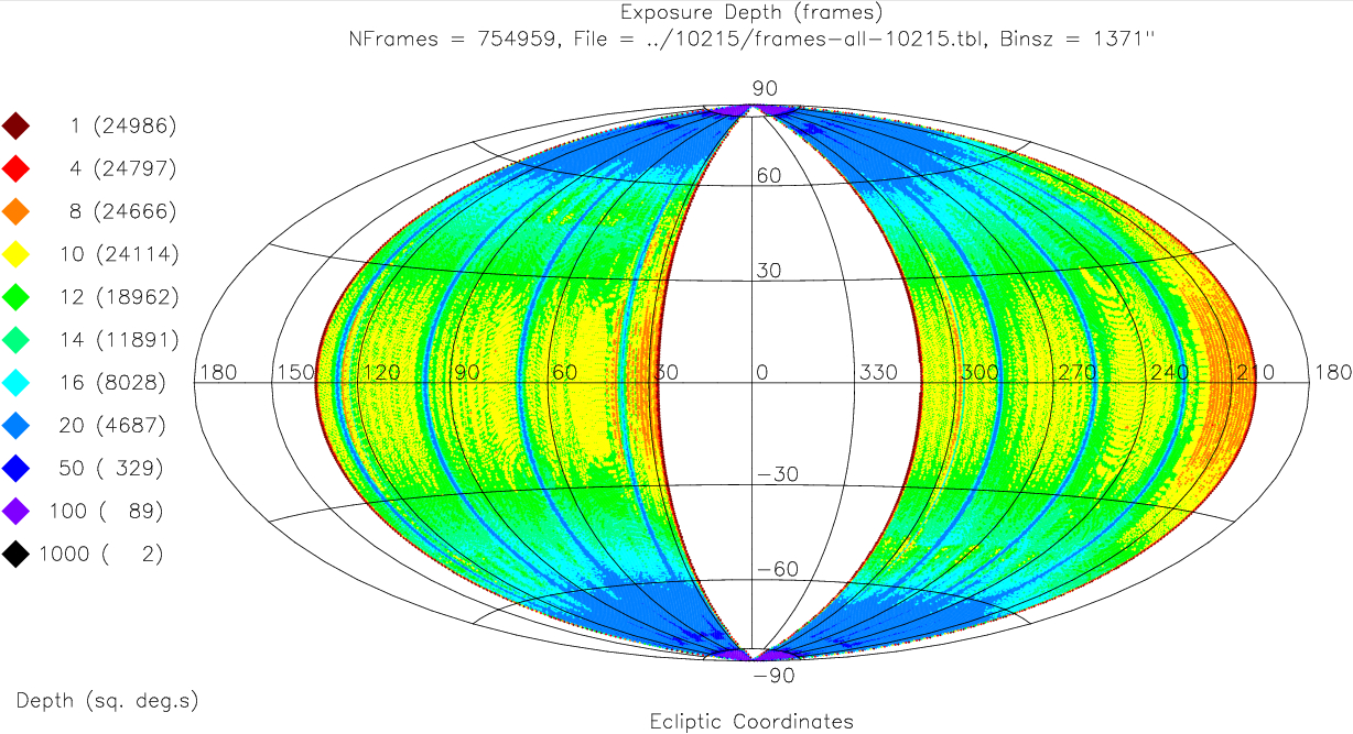
The area of sky covered by these scans is shown in Figure 1. The
coverage region spans two broad ecliptic longitude ranges, approximately
27°<λ<133° and 201°<λ<310°.
The frame depth-of-coverage nominally provided by these scans is
illustrated by the different colors in Figure 1. The coverage depth ramps
down at the outer longitude boundaries because of the progression of scans
across the sky dictated by the WISE
survey strategy.
The Single-exposure Images and
Source Database contain the
calibrated image sets and extracted source lists from all 754,854 of the
framesets contained in the 3,192 scans included in the scope of the
Preliminary Release.
 |
| Figure 1 - Ecliptic sky plot showing the raw
frameset depth-of-coverage for scans 00936a and 04125a. The key on the
left side of the image indicates the depth of coverage encoded by
each color, and in parenthesis, the cumulative area (in square degrees)
having that coverage or greater. This is not the Preliminary
Release area coverage. |
b. Tile Selection
The full sky is tessellated into 18,240 Atlas
Tiles for the purpose of coadding Single-exposure images and extracting
sources in Multiframe processing. The subset
of Tiles used for the WISE Preliminary Release was selected such that all
Tiles were fully enclosed within the scan coverage area shown in
Figure 1. Additional clearance from the outer longitude boundaries was
required to ensure a minimum of six frameset coverages, on average, to insure
effective pixel outlier
rejection in the image coaddition processing. Six or more coverages
are achieved by the selected scans within the ecliptic longitude ranges
27.8°<λ<133.4° and 201.9°<λ<309.6°.
10,466 Atlas Tiles are fully contained
within these longitude ranges. Two of these tiles that
were closest to the ecliptic poles, 2691p651 and 0909m682, were excluded
from Multiframe processing because their extreme coverage depth exceeded
memory limitations in the first-pass processing Multiframe pipeline. These
Tiles will be included in the second-pass processing and final data release.
Table 1 contains a listing of the names
(coadd_id) and position information
for the resulting 10,464 Atlas Tiles that comprise the Preliminary
Data Release Atlas and Catalog area.
c. Frameset and Frame Selection
Not all of the 754,854 framesets contained in scans 00936a through 04125a
were used in the Preliminary Release Multiframe processing. Framesets,
and in some cases individual band-frames were excluded from the image
coaddition step if they did not satisfy minimum quality requirements for
the survey. Frameset and frame exclusion was done both as a static
filtering of the inputs to the Multiframe pipeline, and as
dynamic frame filtering in the coaddition
step (IV.5.a).
Framesets and/or frames were filtered out of the inputs to the
Multiframe pipeline (i.e. static filtering) in the following cases:
- Zero quality score - 31,522 framesets were excluded from Multiframe
processing because they were assigned a net
quality score of zero during the
Scan/Frame processing
Quality Assurance step.
Zero quality scores were assigned when a frameset failed to complete
scan/frame processing successfully for any reason, if the frameset exhibited
degraded image quality caused by spacecraft tracking excursions, or if
high noise levels due to scattered light from the moon or other very bright
sources or elevated electronic noise levels were diagnosed in the images.
- Anneal recovery periods - The W3 and W4 frames in framesets taken
within 2000 seconds following annealing of those detectors were excluded
from Multiframe processing. Temperature annealing of the Si:As detectors
was performed twice per day to eliminate accumulated long-term latent images
produced by bright sources. It required approximately 2000 seconds for
the responsivity, dark current and noise characteristics of the
W3 and W4 detectors to recover to their pre-anneal levels. The W3 and W4
frames in 18,019 framesets with quality >0 were excluded because of
the post-anneal recovery. The W1 and W2 HgCdTe detectors were not affected
by the anneals, so are included in Multiframe processing.
The DTANNEAL keyword in the Single-exposure
image headers provides the elapsed time since
anneal (in seconds) for all framesets. That quantity is also
available as the dt_anneal in the Single-exposure (L1b) Image
Inventory tables.
- Special test observations - A non-standard W4 detector bias setting
was used for the purpose of in-flight testing during 11 scans, 03752a through
03761b, taken on 4/16/2010 UTC. The W4 frames in these scans were not
used for Multiframe processing. This affected 2668 framesets that have a
quality score >0. The W1, W2 and W3 frames in these framesets were used.
Dynamic frame rejection was carried out in the image coaddition
subsystem (IV.5.a.vi) during Multiframe
processing. This filtering identified and excluded image frames
that contain a large number of aberrant pixels as tagged in the
Single-exposure Bit Masks.
Frames were rejected if they are heavily contaminated by scattered moonlight,
large numbers of saturated pixels, or large numbers of
glitches and cosmic rays. The bad pixel rejection thresholds and general
rejection process is described in IV.5.a.vi.
The total number of frames that contributed to the full set of
coadded Atlas Images for the Preliminary Data Release in each band
is listed in Table 2. The frame count differs between bands because some
of the static and all of the dynamic frame filtering was
band-dependent. Approximately 92%, 92%, 89% and 88% of the frames
acquired in the 754,854 framesets in the first 105 days
of the WISE survey are included in the construction of the Image
Atlas and Source Catalog, in W1, W2, W3 and W4, respectively.
Table 2 - Number of Frames Used in Mulitframe Processing for the Preliminary Data Release
| Band | Number of Frames |
| W1 | 693,143 |
|---|
| W2 | 692,031 |
|---|
| W3 | 668,388 |
|---|
| W4 | 665,429 |
|---|
In addition to the frameset and frame-level filtering,
pixel-level outlier rejection was performed
during the Multiframe pipeline coaddition processing. Pixel outlier
rejection affects the coverage on smaller scales in the resulting Atlas
Images that can be tracked by their corresponding
Depth-of-Coverage Maps. The coverage that
was available for the measurement of each Catalog source is tabulated
in the Catalog w1m, w2m, w3m and w4m
columns.
The achieved depth-of-coverage after static and dynamic frameset and
frame filters, and pixel-level outlier rejection in the Multiframe processing
is shown in Figure 2. A detailed discussion of survey and data release
sky coverage is given in VI.2.
Comparison with the original coverage area of the survey's first 105 days
(click on the Figure 2 thumbnail to do this interactively), illustrates
several differences of note.
The ecliptic longitude boundaries of the Atlas and Catalog are pulled in
from the original boundaries because of minimum coverage requirements.
The Release does not cover the ecliptic poles because those Tiles
are not fully contained in the survey boundaries from the first 105 days.
The actual boundaries of the Atlas coverage area are not smooth in
ecliptic longitude because the Atlas Tiles are laid out in an equatorial
grid. There are selected areas with a notable loss of coverage within
the general boundaries of the release. Most significant are the
horizontal bands at λ,β= 100°,+45° and 290°,-45°.
Early in the survey, the spacecrafts' magnetic torque rods were enabled
to dump accumulated momentum when scans approached within 45° of the
ecliptic poles. Activating the torque rods resulted in a small
jump in the telescope pointing and smearing of the resulting images.
Because the smearing occurred near the same point on each orbit, and
the smeared images were flagged as having degraded image quality
in the QA process, low-coverage "holes" developed at those locations.
Later in the survey (2010 May 02), torque rod enabling was staggered between
45, 57.5 and 70° latitude on alternating orbits so that any image
smearing would not occur at the same point on the sky on each orbit.
Framesets that contribute to each Atlas Image are tracked
in the Preliminary Release Atlas Image Frame Cross-Reference
Database. This table contains a listing of frameset identifiers
that correspond to each Atlas Tile in each band. This table can be used
to determine which framesets were used to construct a particular Atlas
Image, or to determine to which Atlas Images a particular frameset or
frame contributed.
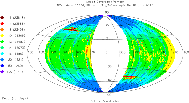 |
| Figure 2 - Net Coverage in W1 for the WISE Preliminary Data
Release. Colors encode the average frame depth-of-coverage in 15x15 arcmin
spatial bins. Click on this image to view a larger version that
allows an interactive comparison between the achieved coverage and
raw scan coverage prior to Tile selection and frameset and frame filtering.
|
Last update: 2011 March 28
Previous page Next page
Return to Explanatory Supplement TOC