II. User's Guide to the WISE Preliminary Data Release
3. Atlas Images
g. Astrometry of Image-derived Source Positions
As noted in section I.4.c, there will be a
systematic difference between the equatorial (J2000) positions of
sources determined off Atlas Images, e.g., via a flux-weighted centroid
or peak-finding algorithm,
and astrometrically calibrated positions from the WISE source catalog, or any
other astrometric reference catalog.
These biases originate in the single frame exposure
(Level 1) images and manifest themselves as source-peak to astrometric offsets
in Atlas Image (co-add) products. The latter are more discernable by eye due
to the relatively higher signal-to-noise and spatial sampling provided
by frame overlaps. Please note that a fix is in place to remove these
biases in the final release. Below we provide a
procedure to correct image-derived source positions and
the WCS in Atlas Image FITS headers in general.
The magnitude and direction of these biases are fixed in the Level-1
image x,y coordinate frame (Table 1),
although they vary with location
on the sky in the x,y system of Atlas Images. The latter is brought
about by the varying angle between survey scans and Atlas Image footprints,
with the variation being strongest as one approaches an ecliptic pole.
The biases are also band-dependent and cause source peak emissions to be
misaligned when multi-color images are made
using the default WCS from each band-specific Atlas Image
(e.g., Figure 1).
The absolute (radial) differences between
source-peaks and "true" astrometric positions
anywhere on the sky are no larger than ~0.50, 0.26, 0.26, and
1.4 arcsec in bands 1, 2, 3, and 4 respectively.
We strongly advise using the catalogued source position if available,
otherwise, if you would like the equatorial coordinates of a source
in an Atlas Image not in the catalog, e.g.,
because it didn't satisfy the catalog selection criteria,
and you desire an accuracy better than that quoted
above for a given band, we recommend the following procedure.
i. Methods to correct image-derived coordinates and WCS
- Query the WISE source catalog
for the footprint spanned by your Atlas Image tile. At minimum, you
will need ra, dec, wx, wy - the equatorial and Atlas Image
based pixel coordinates. You may need to explicitly
pre-select the wx, wy fields before submitting
your query. These positions will represent your
"true" astrometric positions and we relabel them:
RAt, Dect, xt, yt
respectively for use below. Note that
in general, you can use any astrometrically calibrated catalog. The
only difference is that you won't have immediate access to the
pixel positions xt, yt for
expediting the optional estimation of global/statistical corrections
in step 4.
- Overlay these positions on your Atlas Image using an interactive
image viewer,
e.g., DS9
or IPAC Skyview
to get a sense of the source-peak to astrometric position bias.
Note that these biases may be hard to see by eye
since they're typically no larger than ~one-third of a co-add pixel
for bands 1, 2 and 3 and ~one pixel in band 4 (see measures quoted above).
Figure 1 shows an example for bands 1 and 4.
- If you're interested in the equatorial positions of a few uncatalogued
WISE sources in your field (call them RAu, Decu)
and the source-peak to astrometric biases are easy to see for
the brighter sources,
you can measure the peak positions for the latter (RAp,
Decp) and corrections therefrom manually:
δRA = RAt - RAp,
(Eq. 1)
δDec = Dect - Decp,
then use these to estimate your unknown astrometric positions:
RAu = RAp - δRA,
(Eq. 2)
Decu = Decp - δDec.
Caution must
be exercised near an equatorial pole due to the strong Dec dependence
of the correction along RA. Here you will need to
use RA corrections calibrated at approximately the same Dec
as your unknown source positions (if available),
otherwise we recommend using the more generic pixel-based coordinate
method in step 4.
- We recommend the method below if either:
- you'd like to derive the astrometric positions for
many uncatalogued sources
in your Atlas Images, or
- the position biases are too small to enable a manual
astrometric calibration as outlined in step 3, or
- you'd like to create properly registered multi-color
Atlas Image overlays.
First, you'll need to estimate the corrections statistically
in the x,y coordinate system of each Atlas Image using
all available astrometric positions for a given band, i.e.,
δx = xt - xp [pixels],
(Eq. 3)
δy = yt - yp [pixels],
where xp, yp are "source-peak" positions measured
as either positions of the maxima of source signals,
or intensity-weighted centroids
measured within apertures centered on your astrometric priors
xt, yt.
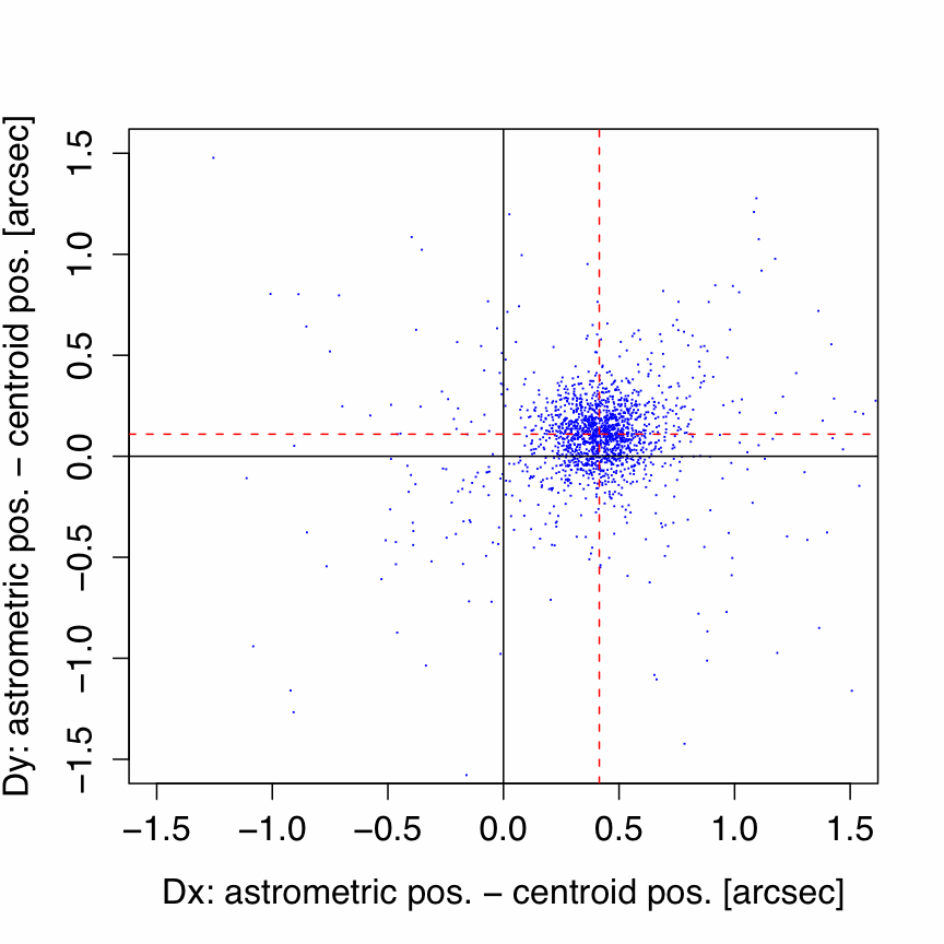
A scatter plot of the corrections for a band 1 Atlas Image
is given in Figure 2. After computing the
median or trimmed-average
correction along each axis, ⟨δx⟩, ⟨δy⟩, these
can be applied to the reference-pixel WCS keywords
CRPIX1,CRPIX2 (always = 2048, 2048) in
Atlas Image headers:
CRPIX1new = 2048 - ⟨δx⟩
(Eq. 4)
CRPIX2new = 2048 - ⟨δy⟩
After replacing the CRPIX1,CRPIX2 values
in your Atlas Image FITS header with those from Eq. (4), you can
re-extract your sources and they will be astrometricaly calibrated.
Dangers at the equatorial poles are circumvented if your
source-finding/extraction software properly handles WCS
transformations when converting from pixels to RA, Dec.
 |
 |
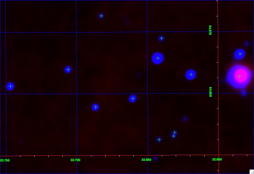
| Figure 1 - Atlas Image zoom-in with overlay of bands 1
(blue) & 4 (red) showing misalignments
between source centroids (or peak emission)
across bands, and with
astrometric positions (green crosses).
Field measures ~3.6′ x 6′ and was taken
from tile 0229p545_aa11. Coordinate grid is
equatorial with North up, East to the left. |
Figure 2 - Distribution of differences between
source (flux-weighted) centroids and
astrometric positions (from WISE catalog) for the
full band 1 tile in Figure 1. Red dashed lines
mark the median corrections on each axis. |
ii. Source Position Biases in Level-1 Frames
For reference, Table 1 summarizes statistics for differences
between source positions derived
from flux-weighted centroids and astrometric ("truth" positions) in the
x,y coordinate system of Level-1
frames (not the Atlas Image x,y system). These are measured
in the sense:
δ = astrometric position - image-derived centroid.
These statistics are based on combining measurements from several-hundred
Level-1 frames over the sky (or at least 5000 point-sources in total
per band) and were computed using a trimmed median. As mentioned above, the
offsets in Table 1 (magnitudes and directions)
do not vary with location of the frame
on the sky, but those in Atlas Images do. Therefore, please do not use Table 1
for correcting the Atlas Image WCS. Use the procedure outlined in
section II.3.g.i instead.
Table 1 - Source-position biases in x,y
system of Level-1 frames
| Band |
δx
[arcsec] |
σδx
[arcsec] |
δy
[arcsec] |
σδy
[arcsec] |
δr
[arcsec] |
| 1 | -0.441 | 0.009 | -0.192 | 0.010 | 0.481 |
| 2 | -0.239 | 0.008 | 0.086 | 0.006 | 0.254 |
| 3 | -0.047 | 0.015 | -0.251 | 0.014 | 0.255 |
| 4 | 1.211 | 0.0233 | 0.664 | 0.032 | 1.381 |
Notes to Table 1
- δr in last column = √(δx2+δy2).
- To convert these offsets to approximate
native Level-1 frame pixel coordinates,
divide by 2.75, 2.75, 2.75, 5.5 arcsec/pixel for
bands 1, 2, 3 and 4 respectively.
Last update: 2011 February 14
Previous page Next page
Return to Explanatory Supplement TOC